Sim Challenge 4: Trusting the Wrong Gidepath (IFR)
Sim Challenge 4: Trusting the Wrong Glidepath (IFR)
A clean vertical path on your navigator can be a wonderful thing—right up until it points you toward terrain on short final.
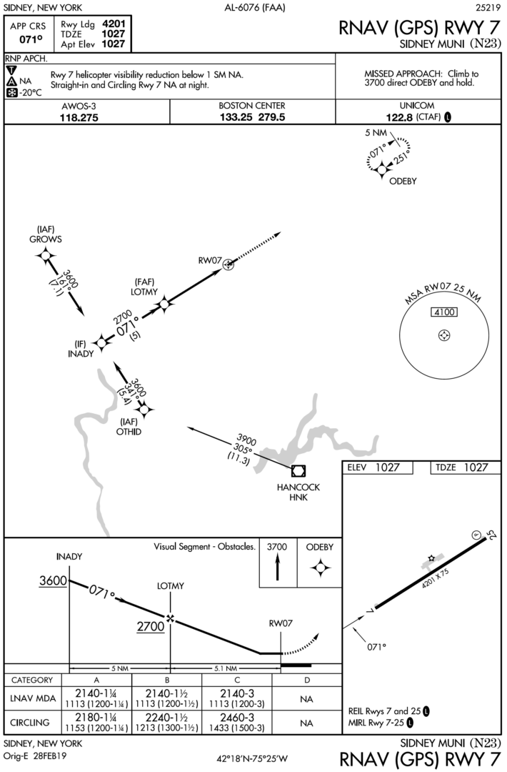
Tricky approaches usually look tricky: high terrain on all sides, steep vertical angles, short runways, or last-minute turns to line up for landing. This Sim Challenge is a tricky approach that doesn’t look it: the RNAV (GPS) RWY 7 at Sidney, NY (N23).
It only offers LNAV minimums, but there is an advisory glidepath. That’s “LNAV+V” in this case. You’ll fly it twice: once in clear weather and once in the clouds.
Spoiler alert: The first attempt will be flown with a fatal error and end prematurely. The takeaway here is how and why that happens—and what to do about it on the second attempt.
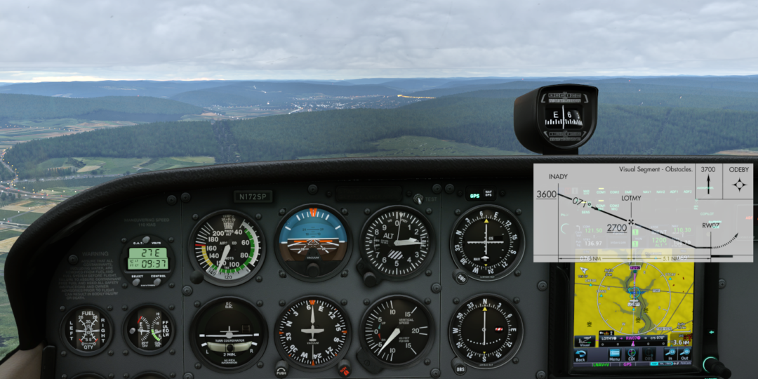
This isn’t some quirk of the simulator. The RNAV (GPS) RWY 7 is a published procedure that complies with all TERPS requirements, but hides a huge gotcha behind a chart note that provides the only heads-up that you must be on guard: “Visual Segment – Obstacles.” A similar scenario may have played a role in the fatal crash of an Epic E1000 at Steamboat Springs, CO (KSBS). The investigation is still ongoing, so we don’t know exactly what happened. But misunderstanding what advisory vertical navigation is—and is not—is a likely culprit. For a deeper dive on this issue, see our companion IFR Focus article, “What Lies Beneath the MDA.”
Time to Fly: ~30 minutes
Aircraft Used: Any IFR GPS-equipped single-engine aircraft (such as a Cessna 172, Cirrus SR22, or similar).
Avionics Required: You’ll need a GPS that can do advisory (+V) glidepaths. Stock X-Plane 12 and Microsoft Flight Simulator 2024 can do this, but it’s not the official guidance so we can’t guarantee it’ll work as needed. If you want to be sure it works like the real thing, use a third-party navigator, such as the TDS GTNXi or equivalent. This is a more-than-worthy upgrade if you don’t already have it. Lacking this, you can get a general idea of the issue by crossing LOTMY at 2700 feet, then descending at roughly 600 FPM at 100 KIAS. It’s less authentic, but still makes the issue apparent.
An autopilot is also handy for full effect.
Tasks:
- Follow an advisory glidepath and INCORRECTLY descend below MDA (once)
- Follow an advisory glidepath and correctly follow the advisory glidepath to MDA
- Continue level at MDA until descent can be made safely … or a missed approach is commenced
Skills Practiced:
- Distinguishing advisory vertical guidance from approved vertical guidance
- Briefing “Visual Segment – Obstacles” and other cues related to guidance below the MDA
- Deciding when a normal visual descent from MDA can be safely accomplished
Relevant Charts
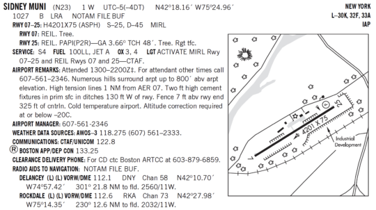
N23 Chart Supplement
N23 RNAV (GPS) RWY 7
Look Out Below
| CONFIGURE THE SIMULATOR |
| Airport/Position: Approaching OTHID (the IAF) on the RNAV (GPS) RWY 7 at N23 at 3600 feet.
Time: Daytime Weather: Clear VFR. Other: Brief the approach as you would for any other small-airport RNAV (GPS) approach either before you begin or once you unpause the simulator. |
| UN-PAUSE THE SIMULATOR |
- Load and activate the RNAV (GPS) RWY 7 at N23 starting at OTHID.
- Configure the airplane normally for an approach and cross LOTMY at 2700 feet.
- If possible, fly this as an autopilot-coupled approach.
- Follow advisory vertical guidance as though it were a real glidepath. (If you don’t have a simulated GPS that can do +V glidepaths, just begin a descent of roughly 600 FPM after LOTMY at about 100 KIAS, which will approximate a 3° glidepath).
- Call out approaching the 2140-foot straight-in MDA. This is a good habit because you should level off here … but you’re not going to.
- Continue to follow the glidepath below the 2140-foot straight-in MDA. This is not something to do in the real world unless there’s a clear path between you and the runway and you meet 91.175. (Yeah, we keep saying that, but bad or unrealistic habits picked up in the simulator carry over into the real aircraft is a real concern. The moniker is “negative transfer.”)
- Look outside and monitor the relationship between the glidepath presented by your avionics, the terrain, and the runway.
- Don’t touch the controls even though you’ll want to.
- Be glad this is a simulator.
- Really, don’t touch the controls.
- Crash (or pause before the crash if you just can’t stand it).
| PAUSE THE SIMULATOR AND DEBRIEF |
Attempt 1 Debrief
Question 3: Why did a glidepath on the navigator just take you into a hillside?
If you stayed on glidepath, you should have crashed 50-100 feet below the ridgeline, about 1.5 NM straight out from the runway, and while descending through roughly 1500 feet.
Probably nothing felt out of place until the relative motion of the ridgeline made the outcome apparent.
That’s the danger here: The presentation on the avionics of a +V is the same as an LPV, so there’s a false feeling of confidence that you’re just fine.
We only know of three approaches in the U.S. where the advisory glidepath will actually take you subterranean if you make this mistake. But there are many, many more where you would come frighteningly close to the trees, if you were centered on glidepath—worse, if you were drifting a bit low on glidepath.
Question 4: How did the approach chart try to warn you?
Two intentional omissions and two notes tell a story:
- There’s no published glidepath angle on the chart. These won’t be published if the angle required is too steep regardless of the reason.
- There’s no published Visual Descent Point (VDP). These are removed in some cases when there are objects in the visual segment (the section below the MDA) that penetrate the protected airspace. That’s not necessarily your glidepath, but it’s the area around it for safety.
- There’s a note that straight-in and circling are not authorized at night. This is added when there are unlit visual segment penetrations.
None of these are really out of the ordinary. Many procedures have visual segment penetrations. The remedy is often higher visibility requirements or other limitations, so pilots have sufficient opportunity to see and avoid obstacles and/or terrain as they descend from the MDA to the pavement.
- There’s the note we already pointed out: “Visual Segment – Obstacles.”
This is added (and any vertical angle removed) when flight inspection determines that obstacles immediately along the flight path do not provide reasonable clearance.
You just saw why that’s a big deal.
How to Get Down From Here
Now that you know what’s lurking below the MDA, it’s time to use this approach as intended—including the advisory glidepath—but within the bounds of proper procedure. You’ll still have to solve the core problem of figuring out how to get down from the MDA when the chart doesn’t provide you with the typical descent reference.
| RECONFIGURE THE SIMULATOR |
| Position: Reset outside OTHID for the same approach, heading inbound at 3600 feet.
Time: Daytime Weather: Marginal VFR. Overcast 1500 and 3 SM visibility. Other: Rebrief the approach (good practice) and remind yourself you’ll need to see a clear path to the runway before descending below the MDA. Again, do this either before you begin or once you unpause the sim. |
| UN-PAUSE THE SIMULATOR |
- Load and activate the RNAV (GPS) RWY 7 again.
- Proceed inbound and cross LOTMY at 2700 feet.
- If possible, fly this with the autopilot, either coupled or in vertical speed mode for the upcoming descent.
- Follow the advisory glidepath (if you don’t have a simulated GPS that can do +V glidepaths, just begin a descent of roughly 600 FPM after LOTMY at about 100 KIAS, which will approximate a 3° glidepath)
- Level off at the MDA of 2140 feet.
- Continue inbound level at 2140 feet until you believe your visual picture is good enough to see the runway. Then make a normal descent and landing using normal maneuvers.
| PAUSE THE SIMULATOR |
Make a note of your distance to Runway 7, your groundspeed, and what you can actually see outside (Runway? Terrain?).
| UN-PAUSE THE SIMULATOR |
Descend for the runway. If at any point this seems too sketchy, go missed. Otherwise, land, stop, and turn off the runway onto the taxiway.
| PAUSE THE SIMULATOR AND DEBRIEF |
Attempt 2 Debrief
Question 5: What actually justified leaving MDA when you did?
Training focuses on the required visual references in 91.175 (c). That’s the easy part here. The harder part is that getting past the hill before descending can make a normal descent and landing using normal maneuvers tricky.
So the trigger for leaving MDA here should have been that you weren’t too high for a straight-in landing. Hopefully, that went well for you. Or, you went missed because it was harder than it looked.
The advisory glidepath may drop below you when you level off at the MDA, but it can still have value. If it’s a little below you when you feel like it’s safe to descend, that suggests your visual descent is only a bit steeper than the optimal angle. If it is pegged full-scale down, that might hint you’re trying to force something that no longer merits the title “normal.”
Question 6: How normal was your descent?
We’ve already established that there is an inconvenient mountain along the path close to a normal 3° arrival. Delay a bit, and you get something closer to 4°. That solves the terrain issue while still being manageable. Delay too long and it gets sporty in a hurry.
The altitude to lose from the MDA to the threshold is about 1113 feet. At 100 knots groundspeed, that’s:
| Distance from runway | Angle | Descent rate |
|---|---|---|
| 3.3 NM | 3.1° | 540 FPM |
| 2.5 NM | 4.0° | 720 FPM |
| 2.0 NM | 5.1° | 900 FPM |
| 1.5 NM | 6.7° | 1200 FPM |
As a general reference, once you are getting close to 1000 FPM on short final in a light airplane, it’s probably time to go around and try again. If you started down closer than 2.5 miles out, you can see why things got dicey. Of course, this is based on groundspeed, so wind can play a huge factor.
Wrap Up: Who’s in Charge Here?
Advisory vertical guidance is a great tool. Used correctly, it helps you fly a stable approach to the MDA, which sure beats the old dive-and-drive method for non-precision approaches.
The problem is that +V looks a lot like the protected vertical guidance you get with an ILS, LPV, or LNAV/VNAV. This can tempt pilots to treat it like protected vertical guidance, which it isn’t. This is a human-factors issue that’s unlikely to change any time soon.
Your hedge against falling into this trap is briefing those notes and noting the absences. No VDP, or no vertical angle? That “Visual Segment – Obstacles” note? Approach designers don’t do these things arbitrarily. They’re telling you there may not be a clean way to get from the MDA to the runway. An advisory glidepath won’t change that.
Generally speaking, on RNAV (GPS) approaches, if the vertical path could be protected, it probably would have been protected already. That may be an unsatisfying answer, but below the MDA, it’s always a visual procedure, regardless of how you got there. From there, the question is whether what you can actually see supports a normal descent to the runway. After that, the rest is on you.
Extra Challenges
Compare with the other end of Sidney: Fly the RNAV (GPS) RWY 25 and notice how advisory guidance works without such a challenging visual segment.
Change the visibility: Reduce visibility to minimums and ask whether you can honestly see enough terrain and runway environment to comfortably leave the MDA without leaning on the advisory path.
Try it at night: In the simulator only, fly the same profile after dark and appreciate why the straight-in night restriction serves a real purpose.
Compare with approved vertical guidance: Fly an approach to LPV minimums somewhere and compare the glidepath depiction there with what you saw on the advisory glidepath earlier.
Find another one: Pull up another approach with “Visual Segment – Obstacles,” such as the RNAV (GPS)-A at Bradford County, PA (N27).
Want Even More? |
| Fly another Sim Challenge
Or, check out our new interactive twist on aviation quizzes: What’s Wrong? Want to receive Sim Challenges, “What’s Wrong?” quizzes, and our “Pilot’s Tip of the Week” right in your inbox? Sign up here If you already receive our “Tip of the Week” emails, there’s no need to sign up again. We’ll let you know when new Sim Challenges and “What’s Wrong?” quizzes are available. |
