Off-Route Thinking
Student pilots learn by rote the visibility differences between controlled and uncontrolled airspace—and then completely forget about it. It makes little practical difference to most pilots who spend almost all their time in controlled airspace (remember, Class “E” stands for “everywhere.”), even though most of that time isn’t under ATC control.
The concept makes much more sense when we learn IFR: ATC can issue instructions in controlled airspace … and then we learn it’s not that simple. ATC can’t issue instructions below certain altitudes in certain places and with certain equipment not functioning. Some airspace is surveyed for unyielding, aircraft-eating objects and some is not.

This all begins to matter when IFR travel takes you to VFR airports beyond the loving embrace of the surveyed and controlled. An IFR Focus reader posed a great question on this subject that seemed worthy of this article.
The gist of the question was this: Departing an airport without an ODP and then planning a direct flight off the victor airways, how do you plan the departure and climb? Specifically, how do you know how fast you need to climb to reach a safe altitude, such as the Off-Route Obstruction Clearance Altitudes (OROCAs) shown on IFR charts? If you’re passing from an area of a lower OROCA to a higher one, when do you need to start to climb?
This is really a two-part issue, so let’s start with a truly VFR airport that has no instrument approach, and therefore hasn’t been surveyed and has no ODP even if it’s surrounded by mountains. Here you’re really on your own to climb obstacle free until reaching a safe instrument altitude. That could be an OROCA, or it could be an altitude you determine by reviewing the sectional chart and any other obstacle data.
The preferred method is climbing in VMC, but you can get a clearance to climb in IMC. The clearance will probably come only after confirming you can, “maintain your own obstacle clearance.” It will often contain a line, “… upon reaching controlled airspace, fly heading …” or “… upon reaching X altitude …” It’s important to understand that’s not a vector; it’s a clearance. ATC is not assuming responsibility for terrain and obstacle avoidance once you reach that “upon.” Even “radar contact” does not shift responsibility to ATC. It’s still, technically, your burden unless you get a vector. But hold that thought for a moment.
If there is an instrument approach to the airport and there’s no ODP, then it qualifies for a diverse departure. Unless it says otherwise in the same section you find the ODPs, the diverse departure allows for a 200-foot-per-nm climb in any direction from 400 feet AGL to the enroute structure. It assumes you cross the departure end of the runway at a measly 35 feet AGL.
This cone of safety extends 25 nm in non-mountainous areas and 46 nm in mountainous. Even at only 200 feet per mile, 25 miles is already 5000 feet AGL. Make that over 10,000 AGL in the mountains. It’s conceivable that a direct route could have you still climbing below the OROCA, and not inside some MEA, and more than 25 (or 46) miles beyond the airport. But that’s a long climb to not yet be at your cleared altitude and have terrain concerns.
Now, back to you flying level in cruise on your cleared route and off-airway. Off-route cruising requires radar contact (with a few exceptions such as at a MOCA within 22 miles of a VOR, but that’s an aside for this discussion). You must also be above the Minimum Instrument Altitude (MIA) for that area. That would be ATC’s Minimum Vectoring Altitude (MVA) or an MEA, whichever is lower.
This is an obstacle-free altitude by definition. Because of this, ATC will issue a climb if you must reach a higher MIA in your direction of travel, even if you’re off-airway and approaching a higher OROCA. So while you’re technically on the hook for obstacle clearance cruising along off-route, it becomes de facto obstacle clearance from ATC.
Note that your altitude at any point might be well below a published OROCA. See the video for more on that. You’re always welcome to check with ATC on what the MIA is for your current position, and should be especially aware in your climb to your cleared altitude.
Watch This Video:
“Finding MVAs and MIAs”
The URL mentioned in the video:
http://www.faa.gov/air_traffic/flight_info/aeronav/digital_products/mva_mia
Filing for VFR Airports

Because it never comes up in training, many instrument pilots don’t realize they can file IFR to an airport that has no instrument approach at all. Technically, you could even file IFR to a fix or a lat/long if you had a reason. The catch is that ATC can only let you down to their MIA for that location.
If you’re not VFR at that point, you better have an answer for, “Say intentions.” For that reason, you must file an alternate when your destination has no instrument approach, even if the forecast is clear and a million. That alternate doesn’t have to have an instrument approach, however, so long as the forecast allows for a descent to the MIA and landing under VFR.
ForeFlight Question of the Month:

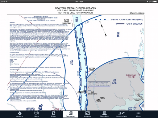
Suppose you want to add a custom FAA chart, such as a Class-B VFR flyway chart, to ForeFlight. These don’t appear in the normal downloads list, so what’s the best way to do that?
A. Download the chart from the FAA website. E-mail it to yourself. Open the attachment in ForeFlight.
B. Download the chart from the FAA website on your iPad. Tap-and-hold on the download and choose, “Open in ForeFlight.”
C. Add the chart directly to the documents section within ForeFlight
D. There is no way to add these lesser-used FAA charts permanently.

