ForeFlight Question of the Month:
Most of the information about icing is found in the imagery section of ForeFlight. To find direct information about actual or predicted icing you should look in:
A. The Icing section of imagery. It’s all collected there.
B. Icing and G- AIRMETs/ SIGMETs
C. Icing, G-AIRMETs/ SIGMETs, and PIREPs.
D. Icing, G-AIRMETs/ SIGMETs, PIREPs, and relevant radar.
Answer: D. Icing information lives is several locations. The icing section of imagery is the best place to start for flight planning purposes, particularly with the Current Icing Potential and Forecast Icing Potential (CIP and FIP) products. However, the G-AIRMET are also a great way to see general icing over an area and time.
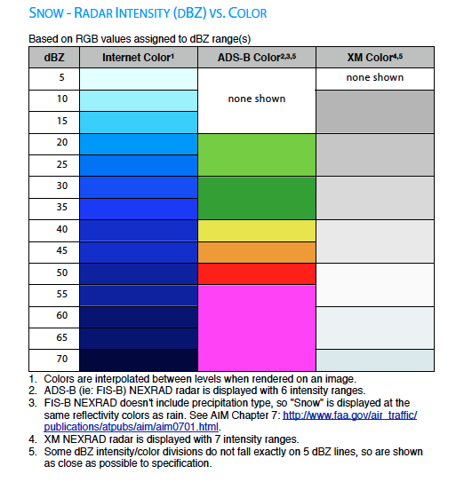
PIREPs are a far timelier method of getting reports of actual ice (or lack thereof), and you can get them in the air with ADS-B or XM. Just remember that icing is notoriously undereported by non-icing-certified GA aircraft.
Color coding on radar can show a probable combination of precipitation and sub-freezing temps—but only when connected to the internet or XM. ADS-B radar only shows intensity, so the color on ADS-B is the same whether that precip is rain, mixed or snow.