It’s easy to get in a rut practicing approaches around your home ‘drome. You know the airports; you know the frequencies; you fly with the same buddy before stopping at the same airport diner for the same pastrami on rye.
Or, maybe you don’t even practice approaches enough to have a “same.” Don’t feel bad; you’re not alone.
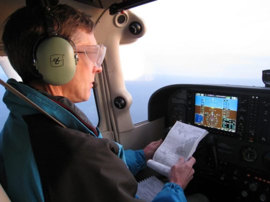
The winter months see more IFR practice than travel for many light GA pilots. So, amp up your practice—and make it more appealing to do on a regular basis. (Set aside the simulator discussion for now. Let’s just talk about real-world aircraft.)
The two best things you can do are making practice a habit and upping the stakes. The first part is pretty simple: Set a recurring day, say the second Saturday of each month, when you and a friend or two go bore holes in the IFR system for practice. Three people are better because two get to watch while one flies, and there’s still a party if one of the gang must take a day off.
Upping the ante on the experience can happen in many ways. Here are a few suggestions:
* Have a focus. Each time you fly, have one thing that’s the core practice for the day. Maybe today it’s partial-panel approaches with an ILS or LPV. That’s all you do. You get to focus on exactly that skill and dial it in. Stick with items that make sense in the real world. If you were really partial-panel, you’d almost certainly find an ILS or LPV, so practicing partial panel without vertical guidance isn’t realistic—unless when you lose your PFD you have no vertical guidance. In that case, partial panel and non-precision would be a great thing to practice.
* Request the option. Rather than ending every flight with a missed approach, let your safety pilot make the call just as you reach minimums or a reasonable visual descent point. You’ll be ready for either. Also, having an option to land might force you to fly a more difficult approach for the runway in use, or fly to circling minimums and circle to the landing runway. Circling is a great skill even if you’d only use it with high ceilings and in daylight. Circle no lower than pattern altitude if you want, but practice maneuvering to land somewhere other than straight-in.
* Remove one thing. This could be a focus topic or something your safety pilot tosses in at random. Just lose one of the tools at your disposal and see what it does to your process. It could be the iPad, your second radio, electric trim, the MFD, flaps, etc. Remove just one thing, however. A variant on this is losing one part of the approach system at the last minute: no glideslope, no GPS position, only an approach with a tailwind available. The key is you don’t know what, or when, until it happens.
* Place a bet. Want to really make practice count? Rate the approaches and have the loser buy lunch. Or the avgas. Believe me, you’ll try harder. The safety pilot must watch for traffic, but if he also has an iPad or tablet, have him grab screenshots for proof. Ideally, the screenshot would show speed and altitude as well as position. ForeFlight or CloudAhoy recordings are great tools for this.
* Debrief. I’m as guilty of not debriefing my own practice as anyone else, even though the instructor in me knows the debrief is as important as the flight itself. Take notes on the other pilot’s flight and have that pilot take notes for you. Use those screenshots as you discuss what happened while you enjoy that lunch. Or beer.
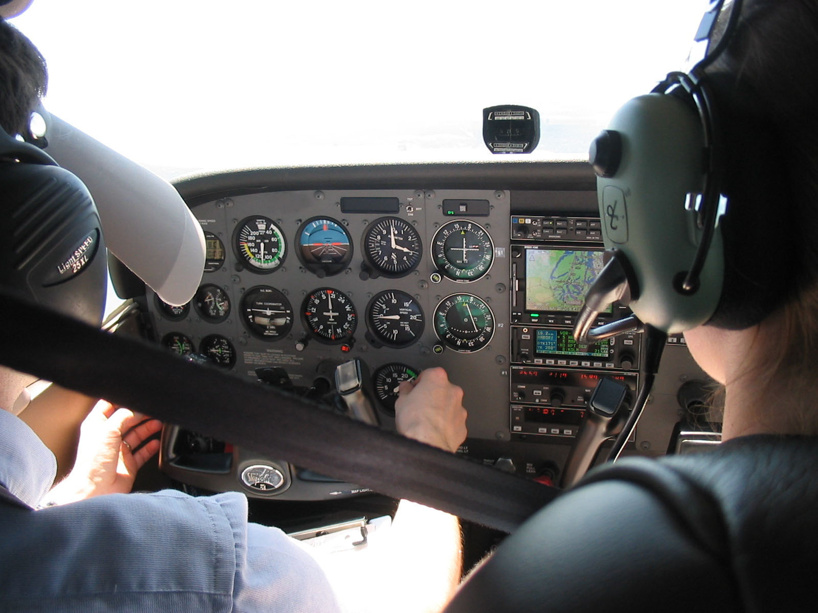
The pilot flying does all the communicating with ATC, except for those requests and traffic calls. A good safety pilot can think ahead and ask for things like alternate missed approach instructions that get you going in the best direction for the next approach, or ask ATC for an impromptu hold to let you catch your breath if things start to fall apart.
Having the right safety pilot is key. You want someone who’s not only legal but knows your airplane and your avionics well enough to give feedback on how you did. If you’re swapping approaches, knowing the equipment is required. It’s helpful to have the safety pilot plan ahead for your next approach request. You also want someone you get along with … and won’t gloat too much when you have to pick up the tab.
Watch This Video:
Practice Approaches and Downgrading GPS Quality
Practice in VFR Conditions
It’s the icing season over much of the CONUS, so practice approaches in clear air are in fashion. This means you can practice without even filing IFR—which is a real boon when your currency has expired. However, VFR practice puts you into a nebulous region where you get some of the ATC services, but not all of them.
The big divide concerns separation services. When these services are provided, you’ll get an altitude to maintain when on an ATC vector. Clearance for the approach means you’re still getting separation from IFR aircraft. When not restricted by ATC, altitude is your discretion. That can confuse pilots when they’re direct to a fix, expecting to get a lower altitude and it never comes. When in doubt, ask. When there are no separation services, altitude is entirely your discretion. In this case, you’ll usually hear, “Maintain VFR. Practice approach approved. No separation services provided.”
Also, keep track of airspace. Talking to ATC for VFR practice approaches meets the requirement for entering Class C airspace, but not Class B or Special Use Airspace. Don’t count on ATC to steer you clear of it.
Reader Question
“Why would the ILS minimums be higher than the LOC minimums on this approach? Thanks! Jon.”
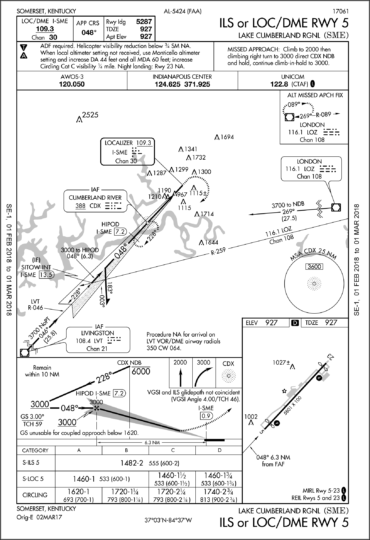
It’s impossible to know for certain without seeing the documentation for the approach, but an obstacle close to the airport is the most likely reason. Possibly it’s that tower shown just off the approach end of the runway. I know it seems odd that you’d have to start an ILS missed approach higher than the Localizer-only MDA, but there are two things to consider:
The ILS has a DA, which is the point where you decide to go missed, but the aircraft will take time and distance to change from a descent to a climb. This must be accounted for. A DA of 1482 feet means the aircraft will descend below 1482 feet as it initiates the missed approach. Less power-to-weight and longer spool up time for the engines means a lower descent below DA before climbing again. It’s not uncommon for heavy commercial aircraft with Cat-II, or -III DAs close to the runway to actually touch down momentarily during a missed approach from minimums.
The shape of the protected airspace is different for ILS versus localizer approaches. It’s possible for an obstacle in just the right spot to affect the ILS approach but not the localizer approach.
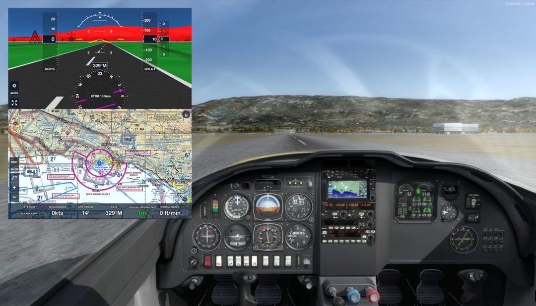
Can you get ForeFlight to work with your desktop flight simulator?
A. Yep. Every feature of ForeFlight can be driven by home simulation.
B. Sort of. You can use real-world weather for both sim and iPad, and receive the GPS position and attitude information from the sim on ForeFlight.
C. A bit. You can receive the GPS position, but that’s it.
D. Not without special hardware. There are cables you can buy, but nothing simple and free.
Your host for IFR Focus is Jeff Van West, former editor of IFR magazine and co-editor of Aviation Consumer. His writing has appeared in AOPA Pilot, Flight Training, AVweb and many other outlets. IFR Focus offers the same practical, humorous, and out-of-the-box thinking Jeff is known for.
As an aviation writer, I'm always on the prowl for interesting approach charts (so if you have a favorite, drop me a line). One that recently appeared in my email was the ILS or LOC Rwy 27 at Williamsport, PA (KIPT). The striking curiosity was plan view note, "RNAV 1-GPS or RADAR AND DME REQUIRED." The investigation yielded a longer explanation than I expected. Too bad I don't get paid by the word.
This note says a transition from the enroute environment to the approach requires either an RNAV 1 level GPS navigator or you a combination of both ATC radar and DME on the aircraft. The lowercase “or” separating the two groups of capital letters means you can have either group of capitals. Don’t send an email if you find an example where these capitalization rules are broken. It’s not consistently employed due to evolving standards for this stuff, but that’s what it means.
(Interesting and vaguely related aside: Did you ever wonder why a writing credit for a Hollywood movie was “Written by Jack Jones & Wilma Mead and Bobby French”? It looks like they couldn’t agree on whether to abbreviate or not, but it means Jack and Wilma wrote as a team, while Bobby wrote separately, and probably later. Same idea as the approach note’s uppercase “and” versus the lowercase “or.”)
The ILS or Loc Rwy 27 at KIPT is hybrid of two approaches. It’s a conventional ILS with the terminal arrival area (TAA) from the RNAV (GPS) Rwy 27 approach grafted on. To transition from enroute to the localizer: Enter one of the three sectors at or above 4300 feet, fly to the initial approach fix for that sector (ZEKNO, JIBGO, or HULRO), intercept the localizer and cross JIBGO, and descend to cross the final approach fix of ZUMEY at or above 3700 feet. There’s no course reversal charted because there’s no direction from which a procedure turn is required, or for that matter, allowed.
Don’t let the “RNAV 1” part trip you up. For our purposes in GPS-driven GA, this means any terminal certified GPS, which must be accurate to within one mile a minimum of 95 percent of the time.
If you have an approach-certified GPS, you’ve got at least RNAV 0.3, which is more than three times an accurate. With that navigator, using the TAA to an ILS is as simple as loading the ILS approach because the waypoints for the TAA will be included.
If you’re still squeezing the life out of an antique GPS that’s terminal only, like the Apollo GX55 in one of the planes I fly, you can’t load approaches, but you can still use its RNAV-1 capability for this approach. The waypoints will be in the database, so if you were approaching from the east via JIBGO, you could enter direct JIBGO and tune the localizer. Navigate via GPS until you’re on the localizer and use the GPS to identify crossing JIBGO. If you were approaching from the northwest, you’d add both ZENKO and JIBGO to your flight plan so you could fly direct ZENKO and then track to JIBGO and then the localizer. That’s not cheating. That’s legitimate use of a terminal GPS that has no approach capability.
If you had no GPS, you could get vectors onto the localizer. This removes the need for the TAA. However, you’d still need to identify JIBGO to know when a descent to 3700 was allowed.
Apparently, ATC can’t help you out with this, or it would say “RADAR” over the JIBGO fix in the profile and plan views. Without that, you’d need DME — or at least RNAV 1 GPS, but then you wouldn’t need the vector in the first place.
A similar situation exists on the missed, where you climb to 980, then make a climbing right turn to intercept MIP R-314 to ZIMEL, which is itself an intersection. With an approach GPS, you simply unsuspend navigation, switch back to GPS guidance and fly to ZIMEL. With a terminal GPS, you can still create a direct-to ZIMEL on a course of 314. This may not be an identical track to flying the VOR radial, but it’s close enough and any difference diminishes rapidly as you approach ZIMEL.
With an approach-certified WAAS GPS, you’d probably skip the ILS entirely and fly the RNAV approach. There’s a pound sign for the DA of 777, which requires a cross-reference. You’ll see a higher-than-standard required climb gradient in the textual missed approach instructions, and that the inoperative table doesn’t apply in the notes. The latter is because the visibility requirement is already 3/4 miles, so you don’t need to add more if the approach lights are out of service.
The Matching Game
Speaking of cross-reference, check out all the inverse (white on black) characters on this plate. Some are simple, others require finding the associated information elsewhere.
At the top of the chart, the inverse A5 by the lights in the briefing strip means this MALSR is at least partially pilot controlled. Likewise, the inverse L by the tower/CTAF frequency means there are at least partially pilot-controlled lights (PCL) when the tower is closed. How do you know the tower will close? That’s what the star after the “Williamsport Tower” in the briefing strip means.
Many folks stop there but don’t be one of them. Down in the airport diagram in the lower left, you’ll see the same inverse L saying it’s the runway end identifier lights (REIL) for Runway 9 and high-intensity runway lights (HIRL) for Runways 9-27 that are pilot controlled. The star here for the medium intensity runway lights (MIRL) for Runways 12-30 means the PCL is non-standard. If you want details, you’ll have to look it up in the A/FD. There you’ll find that the approach, runway, and taxiway lights are controlled via the CTAF frequency—and that the lights for Runway 12-30 are simply off. That could be important information if you’re planning a night arrival after hours. It’s landing Runway 9-27 or going elsewhere.
The inverse T and A indicate non-standard takeoff and alternate-filing minimums, respectively. This time, you’ll reference the chart supplement to see that all departures from all runways demand higher than standard climb gradients and textual departure procedure to follow. These aren’t required for Part 91 flights, but it’s a life-extending practice to comply. Alternately, you could follow the visual climb over airport (VCOA) instructions of climbing in visual conditions to 2800 over the airport before proceeding on course in any direction climbing at least the standard 200 feet per nm.
The non-standard alternate minimums are another lookup, which reveals you’d better have an approach GPS if the tower will be closed, and the forecast weather better be essentially VFR. This is for filing Williamsport as an alternate, not flying there. See the sidebar below for clarification.
Back on the approach chart, the inverse snowflake under the T and A means cold-weather corrections apply to this airport. This requires referencing a document many pilots don’t know exists: Cold Temperature Restricted Airports. You can find it at https://www.faa.gov/air_traffic/flight_info/aeronav/digital_products/dtpp/search/ if you scroll to the bottom of the page. Or you can subscribe to the digital document in ForeFlight. Look in there, and you’ll see the correction only applies to the intermediate legs. There’s no change to final approach minimums.
Two more inverse letters and we’re done. The inverse D in the airport diagram means there’s runway declared distance information available takeoff and landing distances in the A/FD (you’re call whether the D is for “declared” or “distance”). These are the TORA, TODA, ASDA, LDA that sounds like a battle cry in an eastern language, but actually stands for takeoff runway available, takeoff distance available, accelerate-stop distance available, and landing distance available.
The inverse C by the circling minimums is the simplest of all. That means the new circling radii apply, that are both a bit wider, and correct or increasing true airspeed with altitude. See IFR Focus #8 for details.
Speaking of circling, note that circling south of Runway 9 and southwest of 30 is NA at night. Circling to land on Runway 12-30 is also NA at night. These prohibitions are usually because of close in obstacles obstacle you’re expected to avoid visually. If you’re wondering what those obstacles might be, you can find a list after any takeoff minimums and obstacle departure procedures. This might take some time. Williamsport has one of the longest lists of low, close-in obstacles I’ve ever seen.
Maybe the FAA survey folk were getting paid by the word.
Watch This Video:
GPS VLOC Auto Switch and Autoslew
Approach charts like these are a boon to the designated examiner pushing the bounds of a candidate's knowledge on an instrument checkride: "What's the minimum safe altitude (MSA) for this approach?" Search as you may, you won't find the familiar circle with its 25-mile ring of safety on this chart. That's because its equivalent is staring you in the face: The TAA extends out 30 miles from each reference fix with a safe altitude to fly. A published MSA would be superfluous.
[/vip_content]
ForeFlight Question of the Month:
When you’re viewing an approach chart in ForeFlight, what’s the fastest way to see other approaches for that same airport?
A. Close the chart, type the identifier for the airport in the upper right, select the new airport from the list.
B. Load the airport full screen in the Airports tab, then select the other approach from the list of procedures.
C. Swipe left or right on the full-screen approach chart with three fingers.
D. It depends on how you loaded the approach chart you’re viewing.
[post_title] => IFR Focus #19
[post_excerpt] =>
[post_status] => publish
[comment_status] => closed
[ping_status] => closed
[post_password] =>
[post_name] => issue19
[to_ping] =>
[pinged] =>
[post_modified] => 2022-02-10 10:35:50
[post_modified_gmt] => 2022-02-10 15:35:50
[post_content_filtered] =>
[post_parent] => 0
[guid] => http://pilotworkshop.com?post_type=ifr_focus&p=7275
[menu_order] => 0
[post_type] => ifr_focus
[post_mime_type] =>
[comment_count] => 0
[filter] => raw
)
[instructors] => Array
(
[0] => Array
(
[user] => WP_User Object
(
[data] => stdClass Object
(
[ID] => 1265
[user_login] => Jeff_Van_West
[user_pass] => $P$BBFedp8M0WCYT03N4Hh9pJuE9Vxwt30
[user_nicename] => jeff_van_west
[user_email] => jvw@pilotworkshop.com
[user_url] =>
[user_registered] => 2011-01-30 00:00:00
[user_activation_key] =>
[user_status] => 0
[display_name] => Jeff Van West
)
[ID] => 1265
[caps] => Array
(
[instructor] => 1
[bbp_keymaster] => 1
[editor] => 1
[customer] => 1
)
[cap_key] => wp9r_capabilities
[roles] => Array
(
[0] => instructor
[1] => bbp_keymaster
[2] => editor
[3] => customer
)
[allcaps] => Array
(
[read] => 1
[level_0] => 1
[keep_gate] => 1
[spectate] => 1
[participate] => 1
[moderate] => 1
[throttle] => 1
[view_trash] => 1
[assign_moderators] => 1
[publish_forums] => 1
[edit_forums] => 1
[edit_others_forums] => 1
[delete_forums] => 1
[delete_others_forums] => 1
[read_private_forums] => 1
[read_hidden_forums] => 1
[publish_topics] => 1
[edit_topics] => 1
[edit_others_topics] => 1
[delete_topics] => 1
[delete_others_topics] => 1
[read_private_topics] => 1
[publish_replies] => 1
[edit_replies] => 1
[edit_others_replies] => 1
[delete_replies] => 1
[delete_others_replies] => 1
[read_private_replies] => 1
[manage_topic_tags] => 1
[edit_topic_tags] => 1
[delete_topic_tags] => 1
[assign_topic_tags] => 1
[gdbbx_standard] => 1
[gdbbx_moderation] => 1
[gdbbx_moderation_users] => 1
[gdbbx_moderation_report] => 1
[gdbbx_moderation_attachments] => 1
[moderate_comments] => 1
[manage_categories] => 1
[manage_links] => 1
[upload_files] => 1
[unfiltered_html] => 1
[edit_posts] => 1
[edit_others_posts] => 1
[edit_published_posts] => 1
[publish_posts] => 1
[edit_pages] => 1
[level_7] => 1
[level_6] => 1
[level_5] => 1
[level_4] => 1
[level_3] => 1
[level_2] => 1
[level_1] => 1
[edit_others_pages] => 1
[edit_published_pages] => 1
[publish_pages] => 1
[delete_pages] => 1
[delete_others_pages] => 1
[delete_published_pages] => 1
[delete_posts] => 1
[delete_others_posts] => 1
[delete_published_posts] => 1
[delete_private_posts] => 1
[edit_private_posts] => 1
[read_private_posts] => 1
[delete_private_pages] => 1
[edit_private_pages] => 1
[read_private_pages] => 1
[wpseo_bulk_edit] => 1
[instructor] => 1
[bbp_keymaster] => 1
[editor] => 1
[customer] => 1
)
[filter] =>
[site_id:WP_User:private] => 1
)
[override_bio] => 1
[custom_bio] =>
Your host for IFR Focus is Jeff Van West, former editor of IFR magazine and co-editor of Aviation Consumer. His writing has appeared in AOPA Pilot, Flight Training, AVweb and many other outlets. IFR Focus offers the same practical, humorous, and out-of-the-box thinking Jeff is known for.