Subscriber question:
"Before departing on a cross-country flight, which convective forecasts should I be looking at?" - Rick H.
Scott:
“At 55 minutes past each hour or as necessary, the forecaster staffing the convective SIGMET desk at the Aviation Weather Center (AWC) issues any and all convective SIGMETs (WSTs) for the entire contiguous U.S. and coastal waters. Remember that convective SIGMETs are advisories to pilots for active areas or lines of thunderstorms that are significant to aviation – convective SIGMETs are valid for two hours.
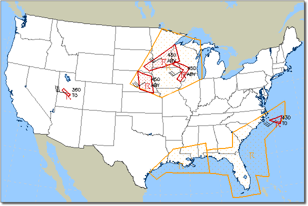
For the forecast period beyond two hours, this same forecaster also issues convective outlook areas for the same region as convective SIGMETs. Convective outlooks represent a time-smeared forecast for thunderstorms and describe larger geographic areas that are likely to see the issuance of one or more convective SIGMETs within the subsequent two to six hour period. These convective outlook areas are outlined in orange as shown in this graphical representation available from the Aviation Digital Data Service (ADDS) website.

Similar to convective SIGMETs, convective outlooks are updated on an hourly basis even when thunderstorms are not currently active as shown by this convective outlook area along the central Gulf coast states. This outlook is a good indication to pilots planning an arrival into Louisiana and southern Mississippi within the next two to six hours, that thunderstorms meeting convective SIGMET criteria should be anticipated.
The Aviation Digital Data Service website provides online access to a textual description of the outlook areas and displays all of the current convective outlooks and convective SIGMETs in graphical form.”
View the current convective SIGMETs and convective outlooks via the ADDS website.
