Subscriber question:
"I see 'MOS' in my list of weather sources after METAR and TAF. What is that and how does it work?" — Dave C.
Not subscribed yet? Sign up here to receive tips like this every week.
Scott:
 “MOS stands for Model Output Statistics. Forecast models such as the Global Forecast System (GFS) don’t automatically produce a point forecast for a specific town or airport, so MOS takes the ‘raw’ model forecast and applies a statistical method that produces an objective, site-specific forecast for a town or airport. MOS forecasts are completely automated, therefore, no human forecaster reviews or amends them.
MOS takes into account historical observations at forecast points such as airports. MOS downscales the model data into weather elements important to aviation. This includes, but is not limited to, cloud coverage, ceiling height, prevailing visibility, wind speed and direction, precipitation type, and the probability of precipitation or thunderstorms.
For example, we know that pressure drives wind. If the GFS model produces a certain pressure pattern over an airport, based on that specific forecast pressure pattern by the parent model, MOS is able to determine that the wind speed and direction will most likely be 290 degrees at 12 knots. That allows MOS to provide a very accurate forecast given that it incorporates the local environment for that airport.
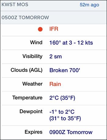
That said, many MOS elements such as ceiling height and surface visibility are categorical. So you might read a MOS forecast of 700-foot overcast and 2 miles visibility, but that really means a forecast with a ceiling category of 500 to less than 1000 feet and a visibility category of 1 to less than 3 miles. In other words, both ceiling height and visibility are in the IFR category.”
Do you rely on MOS forecasts in your flight planning?