Subscriber question:
"Shouldn't a Convective SIGMET warn me of coming thunderstorms, or at least appear by the time the thunderstorms do? Last week I scrubbed a flight because a line of serious thunderstorms was approaching. The Convective SIGMET appeared about 25 minutes later." — Billy Joe B.
Not subscribed yet? Sign up here to receive tips like this every week.
Scott:
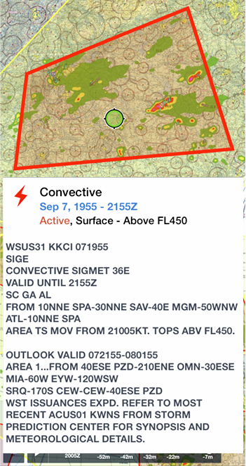
“Often you may hear pilots talk about a ‘Thunderstorm SIGMET’ when in fact, they’re actually referring to a Convective SIGMET. Most convective SIGMETs are issued at 55 minutes past the hour and are a forecast for a two-hour period. But they’re not issued until convection that meets the criteria has already formed and poses a risk to aviation. This means it is likely that convection is already a significant danger to most aircraft even before the first lightning strike.
Specific criteria must be met before a forecaster at the Aviation Weather Center will issue a Convective SIGMET. You may be surprised to learn that lightning is not one of those criteria used by forecasters. Most convective SIGMETs are issued for both areas and lines of thunderstorms, as well as severe and embedded thunderstorms. However, there are dangerous weather systems that consist of deep, moist convection which exhibit little or no lightning. The most common situation where this happens is during ‘low-topped’ convective events where the ingredients for lightning are not present in sufficient quantity. In fact, in some situations, this low-topped convection can even produce severe weather that consists of strong straight-line winds and/or tornadoes.
Although lightning is a dead giveaway for the potential of severe or extreme convective turbulence and possible low-level wind shear, don’t be fooled. A Convective SIGMET means potentially dangerous weather with or without thunderstorms. Keep that in mind when flying around building areas of convection.”
Do you check for Convective SIMGETs and related weather advisories during flight?