Subscriber question:
"When I see a forecast for wind shear should I expect the ride to be bumpy?" - Richard W.
Not subscribed yet? Sign up here to receive tips like this every week.
Scott:
“A forecast for non-convective low level wind shear (LLWS) is perhaps one of the most misunderstood aviation weather forecasts. Understandably so; a pilot hears the term wind shear and immediately jumps to the conclusion that severe turbulence is likely. It’s a common misconception, but non-convective low level wind shear is not a forecast for turbulence. In fact, in most cases, the air is glassy smooth.
The terminal aerodrome forecast or TAF is one place where pilots may see a forecast for non-convective low level wind shear such as the one shown here for Baltimore.
KBWI 152351Z 1600/1706 15006KT P6SM SCT035 BKN070 WS020/19035KT
FM160900 18010KT P6SM BKN020 OVC030 WS020/19040KT…
Additionally, the Aviation Weather Center (AWC) in Kansas City also issues a forecast for non-convective low level wind shear. This forecast, however, is unfortunately labeled as AIRMET Tango. Since most pilots equate AIRMET Tango to a forecast for turbulence, they also believe a forecast for non-convective low level wind shear is also a forecast for turbulence.
The relatively new graphical AIRMETs also issued by the same meteorologists at the Aviation Weather Center takes this a little further and separates the advisory for moderate turbulence with the advisory for low level wind shear. In this example, the low-level turbulence and low level wind shear products are both selected.
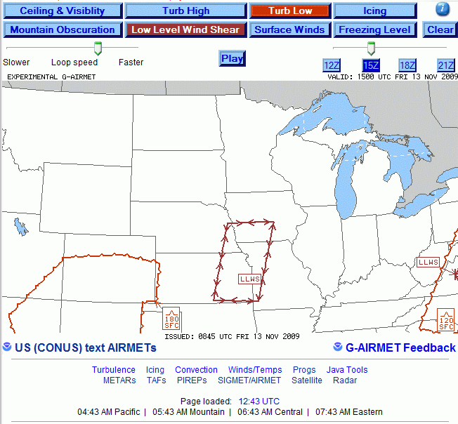
The non-convective low level wind shear forecast simply tells the pilot that the wind will increase by more than 20 knots within the lowest 2,000 feet of the atmosphere. If widespread moderate turbulence were also expected the Aviation Weather Center would have included a separate area similar to the area of moderate turbulence below 18,000 feet shown to the west.
LWC UA /OV OJC270030 /TM 1401 /FL025 /TP H60 /TA 11 /TB NEG
SLN UA /OV SLN135020 /TM 1448 /FL022 /TP H60 /WX FV10SM /TA 14 /TB NEG
As it turned out, there were two pilot reports in this region that reported negative turbulence at 2,200 and 2,500 feet MSL or within 1,500 feet of the surface.”
Online source: http://aviationweather.gov/products/gairmet/
| Note: When the the magnitude of wind shear is significant (> 45 knots) and is coupled with heavy convective rain showers (SHRA, +SHRA, -TSRA, TSRA or +TSRA) these conditions can be hazardous. The momentum from the higher speed winds aloft can be transferred abruptly down to the surface causing dangerous downdrafts including the potential for microbursts. |