Subscriber question:
"I’ve seen internet advice that pilots shouldn’t use vectors-to-final when loading an instrument approach on a GPS. But I’ve never had an issue with it. Is this advice wrong, or have I just been lucky?" — Colin Y.
Jeff:
 “If you were flying around the national airspace, or the internet, in 2007, this would be nearly universal advice. Today … well, it depends on which GPS navigator you’re using and which approach you’re using it to fly.
Here’s the issue: When using the nearly ubiquitous Garmin avionics, loading an approach with the transition as “vectors,” or later activating “vectors-to-final” (VTF), creates a long leg on the final approach course that ends at the final approach fix (FAF). That’s great when you’re being vectored by ATC, because usually you get headings to fly until you’re within about 30 degrees of the final approach course. Then you get an approach clearance, intercept the course shown by that magenta line, intercept the glideslope or glidepath to descend, and go find the runway.
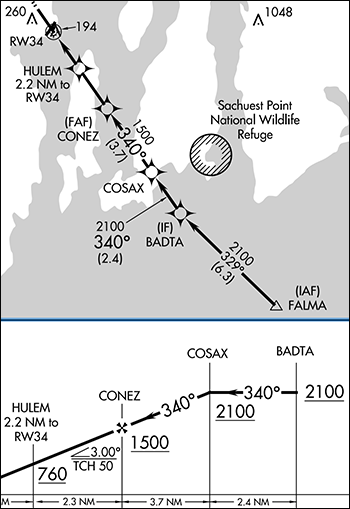
To simplify things for you, older Garmin Navigators (GNS 430/530, some G1000/Perspective) remove all the waypoints outside the FAF when you load or activate VTF. See the RNAV (GPS) Runway 34 at Quonset, RI (KOQU). CONEZ is the FAF here, so COSAX, BADTA, and FALMA will vanish from the moving map and the flight plan.
If you were at 3000 when you intercepted the final approach course between BADTA and COSAX, you could descend to 2100 once established. You could descend to 1500 after crossing COSAX—but it’s not in the flight plan. You could do the math that COSAX is 3.7 miles from CONEZ, which is still in the flight plan, but that’s extra work—unexpectedly—in what’s already a high-workload moment. You could wait for a glidepath, except this is an LNAV-only approach, so the glidepath is advisory only.
Even worse would be if ATC was “vectoring you for the RNAV Runway 34 approach” and you thought that meant all the way to final—and then you heard, “proceed direct BADTA ….” Now you’re really scrambling to reload the approach, scroll to BADTA, push direct … or tell ATC you’re unable to comply with a simple approach clearance.
If instead of VTF, we made a habit of loading the approach from an initial approach fix (IAF), FALMA here, and then activating the leg that ended at the FAF (COSAX to CONEZ), you would keep all the fixes in the flight plan and on the map, in case you needed them later. Even if you intercepted final outside of COSAX, the course needles would still work as expected. This habit was more complicated and error-prone, but arguably worth it.
Newer Garmin systems, like the GTN and similar, keep all the fixes on the final approach course in the flight plan and on the map, even if you use VTF. So COSAX and BADTA would remain, and you could see the distance to any of them with ease. However, fixes not on the final approach course, FALMA, would not be kept. So if you unexpectedly were told, “proceed direct FALMA” you would still have some fast screen tapping to do. But that’s less likely with a fix about 17 miles from the airport. Some quick checking indicates the Avidyne iFDs appear to have a similar issue with waypoints vanishing when using VTF. But I don’t fly that system, so I can’t speak to it, or others like it, in practice.
The point is that it depends on your avionics system. Does it keep or discard these fixes? And it depends on the approach. Are there fixes off the final approach course and outside the FAF that you might need?
Yet again, the aviation answer is: It depends.”
To see more about this, watch Subtleties of ILS Vectors to Final from the course Garmin GTN: Next Level.
What's your primary GPS navigation system?