Subscriber question:
"I hate turbulence—doubly so in IMC. Is there a weather product which gives a good prediction of turbulence, or just severe weather, for a flight planned in the next few days?" — Cathy C.
Not subscribed yet? Sign up here to receive tips like this every week.
Martin:
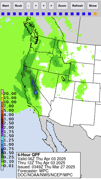 “One of my the first weather products I turn to when trying to get a rough feel for how good or how difficult the weather will be on an upcoming flight is the 6-hour QPF – the quantitative precipitation forecast. It’s available on the Internet and in many EFB apps on our tablets, and shows how many inches of precipitation are expected over the next three days, in six-hour increments.
The idea is simply that large raindrops will have been supported in the air by significant updrafts, before they fall to the ground. Therefore, a correlation can be made between large amounts of precipitation and significant turbulence. We may be able to tolerate inflight rain by itself, especially when flying under IFR; but turbulence can make a flight anywhere from uncomfortable to outright dangerous.
The QPF alone doesn’t tell the full story. Half an inch of rain spread out over the entire six-hour period covered by the chart is probably benign, whereas that same half inch falling in just 10 minutes could create pretty bad flying conditions. The QPF charts show at a glance where the areas are that likely require a closer look in your preflight planning.”
Do you factor potential turbulence into your route planning?