Subscriber question:
"What's the difference between a thunderstorm watch and a warning? And how do those relate to outlooks?" — Jason B.
Not subscribed yet? Sign up here to receive tips like this every week.
Scott:
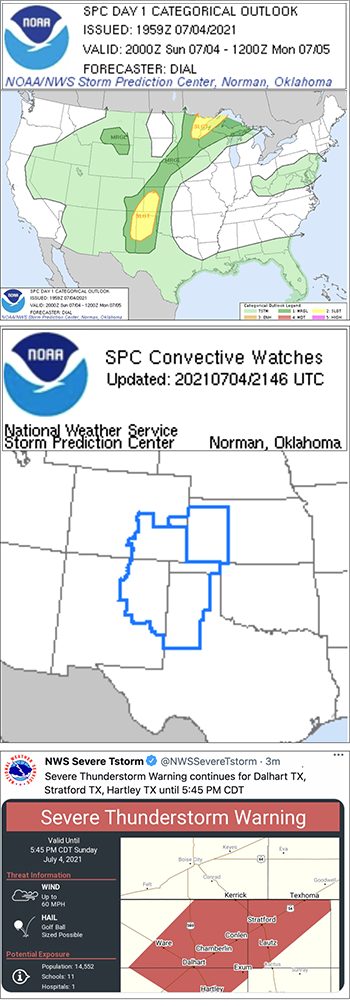
 “When issuing watches or warnings the National Weather Service (NWS) generally uses a three-tiered approach, consisting of outlooks, watches, and warnings. This approach is largely based on two variables: time until the event and certainty of the event.
Outlooks are issued well in advance of the event when conditions are ordinarily uncertain. For example, the Storm Prediction Center (SPC) may issue a severe thunderstorm outlook three or more days in advance of the severe thunderstorm event.
A watch is issued by the NWS when conditions are more favorable and forecasters are more certain for a particular weather hazard to occur. A watch is a recommendation for planning, preparation, and increased awareness. Persons in the watch area should remain alert for changing weather. For example, the SPC may issue a severe thunderstorm watch when conditions are favorable for the development of deep, moist convection that may be severe thunderstorms that might contain strong straight-line winds, large hail, and/or tornadoes.
A warning, on the other hand, is issued by the NWS when a particular weather hazard is either imminent or has been reported. Warnings are ordinarily issued when forecasters are certain of the impact of the weather hazard. Persons in the warning area need to take action immediately to protect life and property. Depending on the specific hazard being forecast, warnings are normally issued 15 minutes prior to the event for severe thunderstorms or tornado warnings. Ordinarily, the geographic region covering a warning is smaller than the watch area for severe thunderstorm or tornado warnings.”
Does having weather data in the cockpit influence your go/no-go decision when thunderstorms are forecast?

