Subscriber question:
"I recently experienced a brief period of moderate to severe turbulence. I was not in an area of convective weather and there was no AIRMET or SIGMET in my area. What caused this?" - Paul M.
Scott:
“Not all pilot reports of turbulence will fall within an AIRMET. In fact, this includes reports of severe turbulence. Outside of deep convection, moderate or greater turbulence can occur in rather shallow layers that are often no more than one or two thousand feet thick.
ROA UUA /OV ROA090010/ TM 1037/FL100/TP E145/TB SEV 100-110=
For example, at 1037 UTC the crew of a regional jet 10 miles east of the Roanoke VOR reported severe turbulence in a layer between 10,000 and 11,000 feet. This likely caught the crew by surprise given that there were no active advisories for moderate or greater turbulence in this immediate area. The closest AIRMET was nearly 70 miles to the east for moderate turbulence below 15,000 feet.
Often turbulence in such a shallow layer is attributed to extreme changes in wind direction and/or wind speed. Depending on the time and location, turbulence such as the crew of this regional jet experienced can be difficult to explain since it tends to slip through the NWS observation network.
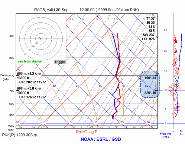
Fortunately, however, at 1115 UTC the NWS releases a radiosonde or weather balloon out of the Blacksburg, Virginia weather forecast office that is located near Roanoke. This radiosonde observation plotted on a Skew-T log (p) diagram clearly shows why the regional jet experienced severe turbulence between 10,000 and 11,000 feet.

While there are only gradual changes in wind speed shown in this sounding, notice the wind shift that occurs at 10,000 feet. The winds change direction from a north to northeasterly flow below 10,000 feet to a southeasterly flow above 10,000 feet. The wind at 10,000 feet is 325 degrees at 15 knots and the wind at 14,000 feet is nearly opposite at 150 degrees at 34 knots. Turbulence produced from this kind of directional shear usually remains isolated to a very shallow layer.”
Online source: http://rucsoundings.noaa.gov

